Point Nemo(or, One Thousand and Four Hundred Miles from Anywhere)What point on the world's oceans is furthest from any land? On a planet with an infinitely complex landmass and ocean distribution pattern, finding such a point might take a fair bit of computing power - or even border on unsolvable. Fortunately, on our home planet this distribution is somewhat simple and a 'heuristic' solution can produce an answer with a high confidence level, in a very reasonable time. The problem can be stated as follows: find the location of a point on the ocean, such that the distance to the closest point on land is the maximum. In the most common case, there will be three such 'close' points on land (actually, on the coastline) with exactly the same distance from the Point Nemo; finding those three points, among many - possibly millions - of the points that represent the coastline is really the best way to conceptualize this problem. The search for those points requires an extremely efficient spatial indexing scheme; one that is capable of organizing geographic coordinates, as any computation in "flat Earth" X/Y plane simply would not work when the geometry problem extends over thousands of kilometers.
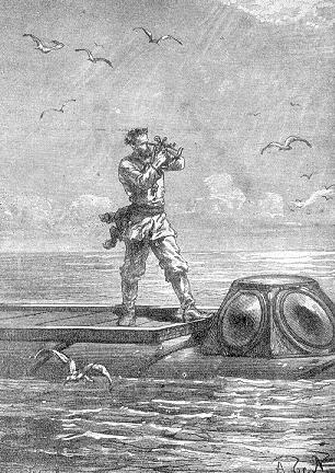
Captain Nemo, from an illustration in the original printing of Verne's novel The name chosen for this point was "Point Nemo". Captain Nemo is a fictional hero of Jules Verne's "Vingt mille lieues sous les mers" ("Twenty Thousand Leagues Under the Sea", 1869): a romantic mixture of maritime exploration, technological wizardry and fearless resistance to the British Empire. Characters such as captain Nemo tend to remain indelible occupants of the memory of those that met them in the literature of their youth. There is a number of different "landmass" data sources, all of some finite precision, and all burdened with some errors. The solution presented here is based on the data from a CD-based publication issued in July of 1992 under the name of 'Digital Chart of the World' (or DCW for short) - put together by what was, at the time, US Defense Mapping Agency (now NIMA) - with the cooperation of Australia, Canada and the UK. However, this data source has a number of errors and omissions, some of which have been corrected before the file was used for this computation. To showcase the precision of the computational software used to solve the problem, the computation was done to a numerical resolution of better than 1mm (one millimeter, or about a twentieth of an inch). In reality, and given the fact that the exact location of the coastline is never surveyed with such high level of precision, is changing over time with both erosion and the continental drift and depends on the state of the tides, a precision of only about a meter or even a couple of meters would be more realistic. However, even if such lower precision was deemed adequate, the distances would still have to be computed as "geodesics" - mathematical lines of shortest distance between two points on the surface of an ellipsoid of rotation.
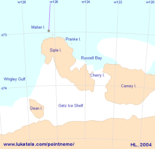
The geographic coordinates of the Point Nemo are: s48:52:31.748 w123:23:33.069 Or, in decimal degrees: -48.875485556, -123.392519167 This point is exactly 2 688 220.580 meters (slightly more than 1 450 nautical miles) away from the following three coastline points: s24:40:39.360, w124:47:25.872 Ducie Island (Pitcairn Island Group, South Pacific) s27:12:29.304, w109:27:33.120 Motu Nui / Rapa Nui ("Easter Island", South Pacific) s72:57:57.024, w126:22:30.793 Maher Island / Siple Island (Antarctica)
In addition to the location of Point Nemo and its three nearest points on land, the map above shows the indexing scheme mentioned in the introduction. The cells are used to organize the land and coastline data for fast spatial search and distance computations. Ducie Island is a small, C-shaped atoll with a diameter of barely two kilometers. It belongs to the Pitcairn group of islands. The first Europeans to visit the island was the crew of Pandora, sailing the Pacific on a failed search for Bounty mutineers. Ducie is not inhabited, but is visited occasionally by those that sail the Pitcairn Island Group. The thin blue line on the map below connects its southernmost point to the distant Point Nemo: 
Ducie Island on a satellite/areal image: 
Motu Nui is a small island (less than 100 meters across) off south-west extreme of Rapa Nui - also known as "Easter Island", as Jakob Roggeveen, the first European to visit it, arrived there on Easter of 1722. Rapa Nui is a 20 kilometer wide volcanic island, perhaps best known for Moai, several hundred giant stone monolith statues that grace its coastline. It can be visited with little effort: the island has an airport and a well-developed tourist trade. The map shows only the south-western tip of Rapa Nui and the miniscule Motu Nui and again, a thin blue line connecting its south-western tip to Pont Nemo: 
Motu Nui on a satellite/areal image: 
The last of three points, Maher Island, is again a small island off a larger island named Siple Island, connected with the Antarctica by Getz Ice Shelf. The map below was prepared using DCW land and ice shelf data; its reliability and completeness in this region is difficult to assess. In this case, the blue line points north - again toward the distant Point Nemo.
Again, for comparison with the above, here is a satellite image of the same area:
Prepared by Hrvoje Lukatela,
date of first publication: March 26, 2004. |